 OneGeology catalogue
GBR BGS Parent Material Soil group
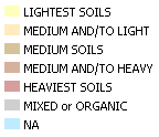
The simplified texture classifications are derived from measured soil textures (%clay, %silt and %sand) taken from archive GBASE and geotechnical samples held by BGS. The samples are compared with a simplified soil-texture triangle used for mySOIL and are grouped by their underlying soil-parent material type to show a map of distribution of the classes; expert judgment has been used to estimate a texture class where sample data is not available). Note that the map uses terms that refer to: Sandy soils, Silty soils, Clayey soils and Loamy soils with additional indicators for the presence of Chalk fragments (Chalky) and Peat (Peaty). Most parent materials generate a broad range of soil textures so these terms should be regarded as 'indicative'. Further information is available from the mySOIL resource page. The GBASE laser granulometry dataset (used in this map later) is also available in the UKSO map viewer.
Simple
- Date (Revision)
- 2022-04-08T08:34:54
- Status
- Completed
- Point of contact
-
Organisation name Individual name Electronic mail address Role British Geological Survey
Garry Baker
enquiries@bgs.ac enquiries@bgs.ac.uk
Point of contact
- Theme
-
-
Map
-
Geology
-
Soil
-
Parent material
-
Soil group
-
Simplified soil texture
-
OneGeology
-
continent@Europe
-
subcontinent@Northern Europe
-
geographicarea@United Kingdom of Great Britain and Northern Ireland
-
dataprovider@British Geological Survey
-
serviceprovider@British Geological Survey
-
DS_TOPIC@geoscientificinformation
-
DS_DATE@2022
-
thematic@Soil
-
thematic@Pedology
-
- Denominator
- 47247.023810
- Topic category
-
- Geoscientific information
))
- Reference system identifier
- CRS:84
- Reference system identifier
- EPSG:4326
- Reference system identifier
- EPSG:4258
- Reference system identifier
- EPSG:27700
- Reference system identifier
- EPSG:3857
- Distribution format
-
Name Version
- OnLine resource
-
Protocol Linkage Name OGC:WMS-1.3.0-http-get-map
https://map.bgs.ac.uk/arcgis/services/UKSO/UKSO_BGS/MapServer/WmsServer? Parent.Material.Soil.group
application/xml
http://metadata.bgs.ac.uk/geonetwork/srv/en/csw?SERVICE=CSW&REQUEST=GetRecordById&ID=9df8df52-d6bd-37a8-e044-0003ba9b0d98&elementSetName=full&OutputSchema=http://www.isotc211.org/2005/gmd& Parent.Material.Soil.group (MetadataURL)
image/png
https://map.bgs.ac.uk/BGS_WMS/legends/soilproperties/pm_soil_group.png Parent Material Soil group (LegendURL)
- Hierarchy level
- Dataset
- File identifier
- 1667cafd5eec8fd0d1e6476798e86db7a3c02b35 XML
- Metadata language
-
eng
- Character set
- UTF8
- Hierarchy level
- Dataset
- Date stamp
- 2022-04-08T08:34:54
- Metadata standard name
-
ISO 19115:2003/19139
- Metadata standard version
-
1.0
- Metadata author
-
Organisation name Individual name Electronic mail address Role British Geological Survey
Garry Baker
enquiries@bgs.ac enquiries@bgs.ac.uk
Point of contact
Overviews


Spatial extent
Provided by
