 OneGeology catalogue
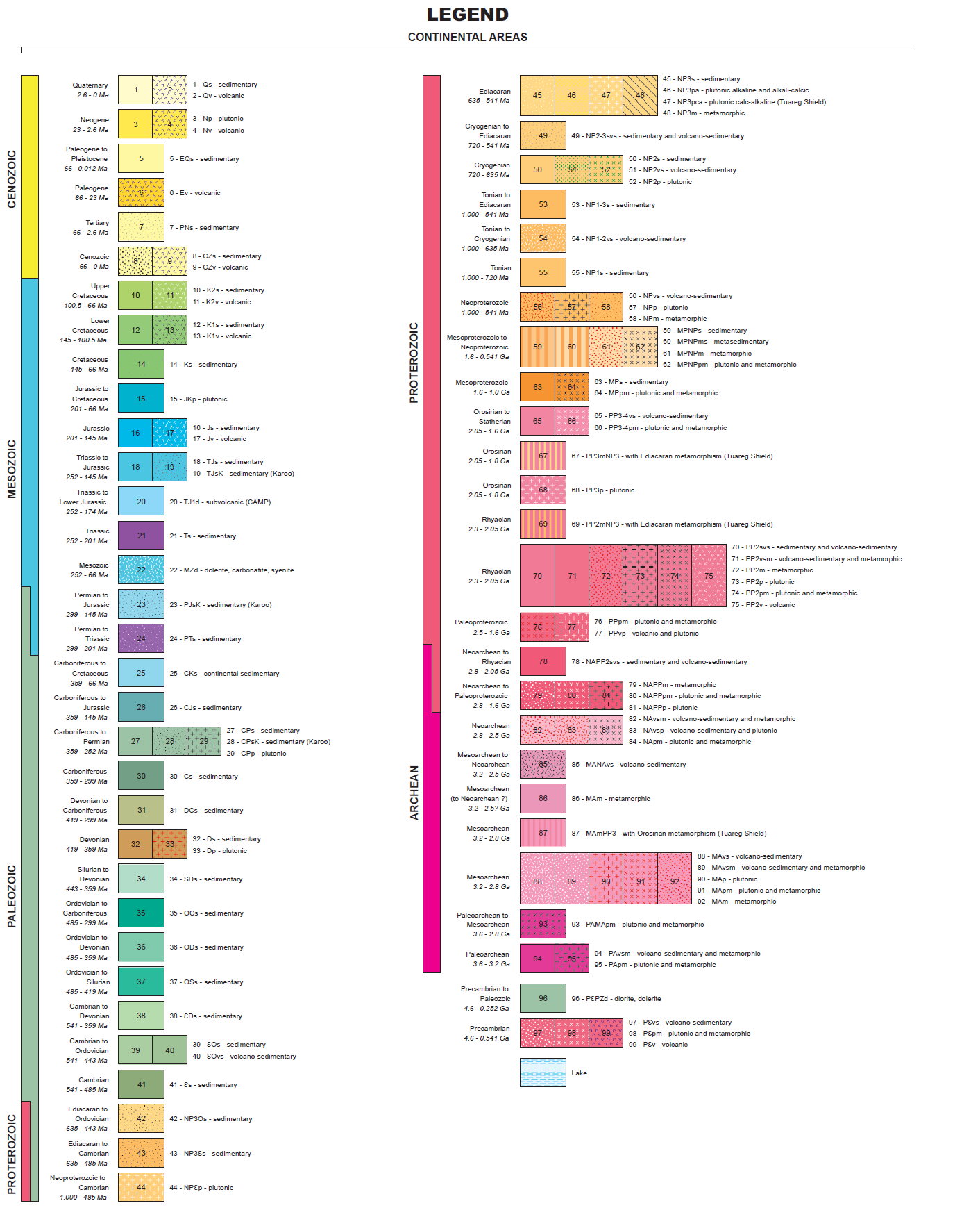
AFR CGMW-BRGM 1:10M Geological units
This 1:10M-scale geological map of Africa was prepared at the French Geological Survey (BRGM) for the 35th International Geological Congress (2016) using the main documents as follows: “Geology and major ore deposits of Africa at 1:10 M scale” (2004); “Geological map of Africa at 1:5 M scale” (1985-1990); “Tectonic map of Africa at 1:10M scale” (2010); the most recent national geological maps when available; regional syntheses (e.g. Tuareg shield, East African Rift). <br><br>The chronostratigraphy as represented on the continental areas of the map refer to the latest version (v2016/04) of the International Chronostratigraphic Chart published by the International Commission on Stratigraphy - www.stratigraphy.org. <br><br>Citation of the map: Thiéblemont D. (edit.) et al. - Geological Map of Africa at 1:10 M scale, CGMW-BRGM 2016. ISBN: 9782917310328. doi: 10.14682/2016GEOAFR. <br><br>Pinted map is available at CGMW (www.cgmw.org) and BRGM (www.brgm.fr).
Simple
- Date (Revision)
- 2016-08-04T10:34:55
- Identifier
- onegeology-geonetwork.brgm.fr/geonetwork3/srv/metadata/4dc1895ea527075510a2ffd524f183d6e996d7c3
- Status
- Completed
- Point of contact
-
Organisation name Individual name Electronic mail address Role CGMW / BRGM
Point of contact
- Theme
-
-
OneGeology
-
Geology
-
Africa
-
Age
-
Bedrock
-
Chronostratigraphy
-
Harmonised age
-
Harmonised geology
-
Surficial
-
Lithology
-
Stratigraphy
-
dataowner@CGMW-BRGM
-
serviceprovider@BRGM
-
geographicarea@Africa
-
continent@Africa
-
MD_DATE@2016-07-21
-
MD_LANG@ENG
-
thematic@Geology
-
thematic@Harmonized geology
-
thematic@Harmonized age
-
- Topic category
-
- Geoscientific information
))
- Reference system identifier
- EPSG:4326
- Distribution format
-
Name Version
- OnLine resource
-
Protocol Linkage Name OGC:WMS-1.3.0-http-get-map
http://mapsref.brgm.fr/wxs/1GG/IGC35_CGMW_BRGM_Africa_Geology? AFR_CGMW_BRGM_10M_GeologicUnits
image/png
http://mapsref.brgm.fr/legendes/ogg/cgmwafrica_fgeol_legend.png brgm (LegendURL)
- Hierarchy level
- Dataset
- File identifier
- 4dc1895ea527075510a2ffd524f183d6e996d7c3 XML
- Metadata language
-
eng
- Character set
- UTF8
- Hierarchy level
- Dataset
- Date stamp
- 2017-05-30T09:44:00
- Metadata standard name
-
ISO 19115:2003/19139
- Metadata standard version
-
1.0
- Metadata author
-
Organisation name Individual name Electronic mail address Role CGMW / BRGM
Point of contact
Overviews


Spatial extent
Provided by
