 OneGeology catalogue
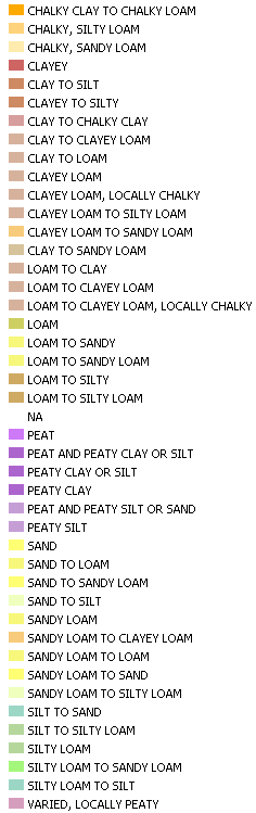
GBR BGS Parent Material Soil texture simple 1km
These generalised soil texture groupings are derived by comparing samples of measured soil textures (%clay, %silt and %sand) against a simplified soil grain-size ternary plot based on DEFRA: Cross Compliance Guidance for Soil Management 2006 and shown below. Note that this map uses terms that refer to Light soils (i.e. sand/silt rich), Medium soils (i.e. loams) and Heavy soils (i.e. clay rich). The classifications are based on analyses of archive GBase and geotechnical samples as well as expert judgment (where sample data is not available). Most parent materials generate a broad range of soil texture so these groupings should be regarded as 'indicative'. The 'Mixed or Organic' classification denotes highly variably textured soils or the presence of Peat (for which no texture data available).
Simple
- Date (Revision)
- 2022-04-08T08:34:54
- Status
- Completed
- Point of contact
-
Organisation name Individual name Electronic mail address Role British Geological Survey
Garry Baker
enquiries@bgs.ac enquiries@bgs.ac.uk
Point of contact
- Theme
-
-
Soil
-
Soil texture
-
OneGeology
-
continent@Europe
-
subcontinent@Northern Europe
-
geographicarea@United Kingdom of Great Britain and Northern Ireland
-
dataprovider@British Geological Survey
-
serviceprovider@British Geological Survey
-
DS_TOPIC@geoscientificinformation
-
DS_DATE@2022
-
thematic@Soil
-
thematic@Pedology
-
thematic@Erosion
-
- Denominator
- 47247.968750
- Topic category
-
- Geoscientific information
))
- Reference system identifier
- CRS:84
- Reference system identifier
- EPSG:4326
- Reference system identifier
- EPSG:4258
- Reference system identifier
- EPSG:27700
- Reference system identifier
- EPSG:3857
- Distribution format
-
Name Version
- OnLine resource
-
Protocol Linkage Name OGC:WMS-1.3.0-http-get-map
https://map.bgs.ac.uk/arcgis/services/UKSO/UKSO_BGS/MapServer/WmsServer? Parent.Material.Soil.texture.simple.1km
application/xml
http://metadata.bgs.ac.uk/geonetwork/srv/en/csw?SERVICE=CSW&REQUEST=GetRecordById&ID=9df8df52-d6bd-37a8-e044-0003ba9b0d98&elementSetName=full&OutputSchema=http://www.isotc211.org/2005/gmd& Parent.Material.Soil.texture.simple.1km (MetadataURL)
image/png
https://map.bgs.ac.uk/BGS_WMS/legends/soilproperties/pm_soil_texture_simple.png Parent Material Soil texture simple 1km (LegendURL)
- Hierarchy level
- Dataset
- File identifier
- 5d9df8a6738bf0c77d817a1a5f1f38800a33db29 XML
- Metadata language
-
eng
- Character set
- UTF8
- Hierarchy level
- Dataset
- Date stamp
- 2022-04-08T08:34:54
- Metadata standard name
-
ISO 19115:2003/19139
- Metadata standard version
-
1.0
- Metadata author
-
Organisation name Individual name Electronic mail address Role British Geological Survey
Garry Baker
enquiries@bgs.ac enquiries@bgs.ac.uk
Point of contact
Overviews


Spatial extent
Provided by
