 OneGeology catalogue
GBR BGS Water wells
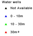
This layer of the map based index (GeoIndex) is a map based index of the National Well Record Archive. This index shows the location of water wells along with basic information such as well name, depth and date of drilling. The index is based on the collection of over 105,000 paper records of water wells, springs and water boreholes. Geological information, construction details, water quality data and hydrogeological data may also be available for some water wells. The amount of detail held on individual sites varies widely and certain fields will have an 'unknown' value where the paper records have yet to be checked for their content. The zero values for the depth represent those for which the depth has yet to be entered into the database from the paper records.
This layer is only available at specific zoom levels. Please zoom to a larger scale to interrogate the map.
Simple
- Date (Revision)
- 2022-04-08T08:20:10
- Status
- Completed
- Point of contact
-
Organisation name Individual name Electronic mail address Role British Geological Survey
Garry Baker
enquiries@bgs.ac enquiries@bgs.ac.uk
Point of contact
- Theme
-
-
Boreholes
-
GeoIndex
-
Water wells
-
OneGeology
-
continent@Europe
-
subcontinent@Northern Europe
-
geographicarea@United Kingdom of Great Britain and Northern Ireland
-
dataprovider@British Geological Survey
-
serviceprovider@British Geological Survey
-
DS_TOPIC@geoscientificinformation
-
DS_DATE@2022
-
thematic@Borehole
-
thematic@Water well
-
thematic@Exploration
-
thematic@Groundwater body
-
- Denominator
- 236235.119048
- Topic category
-
- Geoscientific information
))
- Reference system identifier
- CRS:84
- Reference system identifier
- EPSG:4326
- Reference system identifier
- EPSG:4258
- Reference system identifier
- EPSG:27700
- Reference system identifier
- EPSG:3857
- Distribution format
-
Name Version
- OnLine resource
-
Protocol Linkage Name OGC:WMS-1.3.0-http-get-map
https://map.bgs.ac.uk/arcgis/services/GeoIndex_Onshore/boreholes/MapServer/WmsServer? Water.wells
application/xml
https://metadata.bgs.ac.uk/geonetwork/srv/eng/csw?SERVICE=CSW&REQUEST=GetRecordById&ID=9df8df53-2a73-37a8-e044-0003ba9b0d98&elementSetName=full&OutputSchema=http://www.isotc211.org/2005/gmd&version=2.0.2& Water.wells (MetadataURL)
image/png
https://map.bgs.ac.uk/BGS_WMS/legends/geoindex/ww.png Water wells (LegendURL)
- Hierarchy level
- Dataset
- File identifier
- deb9bc302d7e2be0b8f846fd263735d7026c36f0 XML
- Metadata language
-
eng
- Character set
- UTF8
- Hierarchy level
- Dataset
- Date stamp
- 2022-04-08T08:20:10
- Metadata standard name
-
ISO 19115:2003/19139
- Metadata standard version
-
1.0
- Metadata author
-
Organisation name Individual name Electronic mail address Role British Geological Survey
Garry Baker
enquiries@bgs.ac enquiries@bgs.ac.uk
Point of contact
Overviews


Spatial extent
Provided by
