 OneGeology catalogue
GBR BGS Parent Material Soil layer thickness 1km
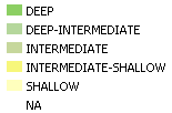
"The simplified texture classifications are derived from measured soil thicknesses taken from archive borehole records held by BGS (see the BGS Soil-sample Depth dataset in the map viewer: http://mapapps2.bgs.ac.uk/ukso/home.html?layers=SamplesDepth). The thicknesses are compared and collated with the expected engineering strength classification of their underlying soil-parent material type to show a map of distribution of the classes; expert judgment has been used to estimate a thickness class where borehole data is not available). Note that the map uses combinations of terms that refer to: Deep soils, Intermediate soils and Shallow soils (see table below).
As a rule of thumb, these categories are based on the ability to manually dig (with a spade) without being hindered by a substrate that is too strong to excavate (i.e. layers of solid rock, dense gravel, or very stiff clays). An example of a deep soil would be one developed over unconsolidated, clayey Quaternary deposits, and an example of a shallow soil would be one found in areas underlain by chalk or limestone. Users should note that land management practices and natural weathering and accumulation (or erosion) processes of soil materials play a significant role in controlling soil thickness (it has not been possible to factor in these influences within the scope of this dataset) and so the classes shown in this dataset should be regarded as 'indicative'."
Simple
- Date (Revision)
- 2022-04-08T08:34:54
- Status
- Completed
- Point of contact
-
Organisation name Individual name Electronic mail address Role British Geological Survey
Garry Baker
enquiries@bgs.ac enquiries@bgs.ac.uk
Point of contact
- Theme
-
-
Map
-
Geology
-
Soil
-
Parent material
-
Soil thickness
-
OneGeology
-
continent@Europe
-
subcontinent@Northern Europe
-
geographicarea@United Kingdom of Great Britain and Northern Ireland
-
dataprovider@British Geological Survey
-
serviceprovider@British Geological Survey
-
DS_TOPIC@geoscientificinformation
-
DS_DATE@2022
-
thematic@Soil
-
thematic@Pedology
-
- Denominator
- 47247.968750
- Topic category
-
- Geoscientific information
))
- Reference system identifier
- CRS:84
- Reference system identifier
- EPSG:4326
- Reference system identifier
- EPSG:4258
- Reference system identifier
- EPSG:27700
- Reference system identifier
- EPSG:3857
- Distribution format
-
Name Version
- OnLine resource
-
Protocol Linkage Name OGC:WMS-1.3.0-http-get-map
https://map.bgs.ac.uk/arcgis/services/UKSO/UKSO_BGS/MapServer/WmsServer? Parent.Material.Soil.layer.thickness.1km
application/xml
http://metadata.bgs.ac.uk/geonetwork/srv/en/csw?SERVICE=CSW&REQUEST=GetRecordById&ID=9df8df52-d6bd-37a8-e044-0003ba9b0d98&elementSetName=full&OutputSchema=http://www.isotc211.org/2005/gmd& Parent.Material.Soil.layer.thickness.1km (MetadataURL)
image/png
https://map.bgs.ac.uk/BGS_WMS/legends/soilproperties/pm_soil_layer_thickness.png Parent Material Soil layer thickness 1km (LegendURL)
- Hierarchy level
- Dataset
- File identifier
- f811995de2d72d8d3e7c3a51e6097ac84f9df91a XML
- Metadata language
-
eng
- Character set
- UTF8
- Hierarchy level
- Dataset
- Date stamp
- 2022-04-08T08:34:54
- Metadata standard name
-
ISO 19115:2003/19139
- Metadata standard version
-
1.0
- Metadata author
-
Organisation name Individual name Electronic mail address Role British Geological Survey
Garry Baker
enquiries@bgs.ac enquiries@bgs.ac.uk
Point of contact
Overviews


Spatial extent
Provided by
